Interactive Flash Astrolabe
User's Manual
You can open the manual and the astrolabe at the same time, side by side.

Chapters
Geoffrey Chaucer
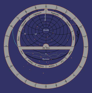
Zenith
Altitude, Angle, Alidade
White Horse
Pole Clock
Latitude, Altitude
Climates
Rete
Sun
Time, Length of Day
Stars
Shadowland
Astrologie
The Horse's Tale
Web Links
Chaucer's Middle English Text
Epact - beautiful display
of ancient instruments
Astrolabe Exhibit at Oxford
Sky and Telescope Magazine
- a source for everything astronomical; includes an excellent interactive sky chart
Janus Probably the original and still the most encyclopedic astrolabe site on the web. Includes a template for building your own Mariner's Astrolabe. Or they will construct a custom made astrolabe for your location.
Keith's Equinoctial Astrolabe
- an elaborate Java construction
Stereographic Projection
- astrolabe geometry explained
Naked Eye Observing
- including Tycho Brahe's mural quadrant
Quadrant - an easily
made measuring device
Greene - builder of
metal reproductions
Geoffrey Chaucer
Toward the end of the fourteenth century there lived in England a man named Geoffrey Chaucer. He was a customs officer of the king and, because of his position, he was able to travel in England and Europe. He met people who owned books (that was not a very common thing then!) and he read as many books as he could get his hands on. He may have read, or at least skimmed thru, most of the books that were then in existence, including some written in Arabic and Italian.
In the Middle Ages very few people could read. And they had to learn the Latin language at the same time. All the books were handwritten - there were no printing presses - and most were written in Latin, even tho none of the people who wrote or read them spoke Latin as their native language. So a book was a very special possession, like a secret world, very expensive to buy, and then hard to understand. But, as you know, reading gets easier with practice. Learning a new language is also hard at first but then much easier once you get the hang of it.
Now when Geoffrey Chaucer decided to write his own books he didn't write them in Latin. He was one of the first people to write in English. You might think he did this to make it easier for people to read his books. But I think he did it because he loved the language of his time and place. And the things he wanted to write about - stories about people acting the way people acted in those days - could be told better in everyday language. In Chaucer's writing we have a sort of word-photograph of the way English people spoke and acted in the Middle Ages. We're lucky he didn't just write in Latin about "serious" things the way most writers of his time did.
Geoffrey Chaucer celebrated the music of his native tongue. And he opened the door a little on the secret world of books, for, besides telling his own stories, he also retold in English some of stories he had read in other languages. After Chaucer, more and more people began writing in English. By now, millions of books have been written in English - and there are millions of copies of some of them! The door is wide open. Step right this way and... But wait. As easy as going to the circus? No. Sometimes the writer of a book and the readers are just clowning around. But other times reading a book is more like being IN a circus - as a lion tamer, for example, or the man on the high trapeze.
In this "book" I've tried to tame one lion for you - the one that guards the distance between Chaucer's fourteenth century Middle English language and our twenty-first century American English language. After 600 years Middle English is almost as difficult for us as Latin was for Englishmen in the Middle Ages. Some twenty-first century people enjoy reading Chaucer's books in the original version. It's really not that difficult. But since most adults nowadays seem to prefer to read modern "translations" of Chaucer's work, I won't expect young people to do any differently. This version of his Treatise on the Astrolabe can be your introduction to the first book ever written in English for young people. You might also like to look at the original.
Actually, the Treatise on the Astrolabe, also called Bread and Milk for Children, was written for one child. Chaucer gave this special gift, along with an actual astrolabe, to a nine year old boy named Lowys (or Louis), who may have been Chaucer's son (we don't really know) or the son of a close friend. Chaucer had noticed that Lowys was interested in "the sciences", and he thought Lowys was bright enough to learn to use an astrolabe. In the Middle Ages a nine year old was considered a young man - no holds barred! And a young man's business was to learn to fight with stick, sword and shield, to ride a horse well, to learn Latin and numbers (or to have it beaten into him if he was a bit slow), or to learn (by working twelve hours a day at it) the trade or profession that was chosen for him.
The modern equivalent of an astrolabe would be a precise and portable instrument useful for surveying (measuring and marking tracts of land) or for astronomical measurements, combined with a computer programmed with most of what was known about the motion of the solar system and the stars. It was also the only way that anyone could accurately tell the time of day or night, so it served as a pocket watch (before clocks or watches existed). We don't have any record of Chaucer giving Lowys any other gifts, but this one was hard to beat.
Lowys had watched certain men pulling just such an "astrolabie" from their pockets on many occasions. Hanging from a small ring, it would hold their attention for a moment, or they would adjust its discs for thoughtful minutes while the rest of the world passed more or less busily around them. Not all the men in his town had an instrument like this - in fact, very few did. But these happened to be the men the boy most admired. He could see that the astrolabe was important to them. Not that they would show it off as a badge of distinction. No. He saw that they were using it to try to understand certain things. And he wanted to feel for himself that quiet pleasure of understanding which he saw in their faces as they put the astrolabes back in their pockets.
The spark in the boy's eye caught the eye of Geoffrey Chaucer. And he responded first with the gift of an astrolabe "compowned after the Latitude of Oxenforde" (their home town), and then with a handwritten twenty page book to help the boy step by step to a gradual understanding of the instrument, and, thru it, to a clear picture of the universe we live in and move thru. Just twenty pages, but probably enough to keep Lowys occupied to well past his twentieth year.
This is not a translation of Geoffrey Chaucer's book. It's my version of an explanation of the same things. The astrolabe we're working with here was made with modern star maps. If you learn to use it carefully, on a clear night you can calculate the time to within fifteen minutes of the actual time. You can calculate sunrise and sunset times for any day of the year for any place in the Northern Hemisphere, as well as how high the sun will be at midday. If you travel North or South you can calculate your Latitude (that's as much information as Christopher Columbus had about his location - he used an astrolabe for navigation).
The astrolabe can help you get a clearer picture of the Earth as a planet in a solar system. It's a portable, flat-faced analog computer that puts you in the total picture in a very real way. Take it with you like a pocket watch as you move around on this giant spaceship.
Closer to ground level it's a rough surveying instrument. Use it to measure the height of mountains, trees or buildings, or how high your model rocket can fly. It's also useful to determine approximate distances to far off visible points.
To understand this model of our universe we'll look at it piece by piece (not necessarily in order from A to Z), all the while trying to see each piece in relation to the whole instrument.
Parts of the astrolabe correspond to parts of the cosmos - the sun, the stars, the horizon. Other parts divide space into sections, showing the precise location of these cosmic objects from our point of view.
Let's start with the point directly above your head.
Zenith
When you stand on a flat piece of ground, with no hills or buildings nearby, and look towards the horizon in each direction, you're looking along the HORIZONTAL PLANE (a plane is a flat surface). Like ants in the middle of a large round tabletop, we walk on a world which is apparently flat, and the horizon wraps around us at the same distance from us in each direction we look. We're at the center of its circle. (No matter where you go you're always at the CENTER of an imaginary tabletop like this - never near the edge).
If you tie a small weight to a string and hang it from your finger, the string will hang at an angle of 90 degrees to the tabletop plane. An imaginary line extended straight downwards from the string points to the center of the Earth. Extended upwards, it points to the spot in the sky which is directly above your head. This is the ZENITH. The string and weight arrangement is called a plumb line - here the word plumb comes from the Latin word for lead, like the lead weight on a fishing line. The weight is pulling the line directly toward the center of the Earth. Builders use a plumb line to check whether their walls are straight top to bottom. Hanging the astrolabe from your thumb or finger is just like hanging a plumb line. The vertical line on its face points down to the center of the earth and up to the Zenith in the sky. The horizontal line on the face of the astrolabe runs parallel to the water level in a pool. If a tabletop were exactly horizontal as seen from all sides a marble wouldn't roll off.
At any given moment, unless we are fairly close to each other, our Zenith will be a different point in the sky. If we're both outside standing in the same field the Zenith will be essentially the same point for both of us, but if you're in New York and I'm in Chicago, at that moment our Zeniths will be quite different points in the sky. Imagine yourself at the bottom of a (dry) well looking up at the night sky. Throughout the night you'll see different stars pass into view, then disappear. The Zenith is the point above your head at any given time. Although it changes constantly, the idea of what it is doesn't change.
Altitude, Angle, Alidade
The ALIDADE, on the front of the instrument, is the flat bar which swivels around the center. Its two ends come in contact with the degree markings around the edge of the circle. Try setting the Alidade at zero degrees, that is, along the horizontal line, carefully putting the ends of its line right on the zero degree markings. Now hang the astrolabe on your thumb and sight thru the two slits at each end of the Alidade (see the drawing) toward some point on the horizon. You'll need some practice at keeping the instrument steady, and also in seeing clearly just where the center of the Alidade slits are pointing to. When sighting with the Alidade slits set on zero degrees the point you see in the distance is at your eye level. If the points are far off in the distance you can consider them to be at the same level as the ground you're standing on. Can you find any points on the horizon which are higher or lower than the place you're standing?
Now try sighting and adjusting the Alidade so that it points to the top of a tree or other object not so far away. Don't forget, you need to do this sighting and adjusting WHILE the astrolabe is hanging from the ring.* When you've adjusted it and checked again so that you're satisfied you see the top of the object right in the middle of the slits, carefully read how many degrees the Alidade is marking on the outer circle. This is the ALTITUDE ANGLE for that object. This will often be called simply the Altitude, but don't forget, it refers to an angle, not to a height.
* A statue of the explorer Samuel de Champlain (one of the Great Lakes is named after him) in the city of Nepean (Canada) shows him holding his astrolabe by its body while he sights thru it. This is NOT the correct way to hold the astrolabe ! I'm sure the real Champlain knew better. In any case, there is an interesting story of how he lost his astrolabe while portaging a canoe at a difficult part of the Ottowa River; it was found 254 years later, in 1867, by a fourteen-year-old boy named Edward Lee who was helping to plough a field.
The Altitude angle you read can be used to calculate the height of an object on the Earth, as I'll explain later, or to calculate the time of day or night by measuring the altitude of a particular star or of the sun (don't look directly at the sun). The stars are sighted directly thru the slits. To find the sun's Altitude angle, hang the astrolabe facing you and turn yourself and the Alidade so that the sun casts a shadow from the higher slit thru the lower slit. Then read the angle on the outer circle of the instrument.
White Horse in the North
On the back of the astrolabe everything turns around the "HORS". She is at the center of its secret. The secret is simple. When you look at the night sky all the stars seem to turn around the Pole Star (or North star), Polaris. At the North Pole Polaris is always at the Zenith. If you were in a well at the North Pole you would always see the same star when you look up.
The stars SEEM to turn around her. Actually, as the Earth turns on its axis it's like riding a huge carousel and looking up at the cosmos. Every day we come around to see the same things again ALMOST in the same position. The sun "comes up" in front of us and "goes down" behind us. Then the constellations pass (from ahead of us in the East they rise above and pass behind us in the West), just as slowly, just as fast as the sun. The "Pol Hors" is the star that all the other stars seem to be turning around. She never seems to move. The center pole that our carousel Earth turns around is called its axis. The Earth's axis points almost directly to the Pol Hors. Always.
Most people know the Big Dipper. It's one of the constellations that are always above the horizon if you're looking from somewhere in the Northern Hemisphere, which is where North America, Europe and Asia are located. The Big Dipper, also known as Ursa Major (the Great Bear) and the Cart, is a good constellation to start with because it's the one that will help us to find Polaris. There are seven bright stars in it. An imaginary line thru the two stars at the front of its bowl points toward Polaris. People who go walking (or riding, or sailing) at night find it very useful to know that Polaris is always due North. It at least keeps them from getting completely lost.
Prehistoric Pole Clock
Sailors also know that an imaginary line from the Dipper to Polaris can be almost as useful as a clock for telling the time at night. If we know the time at some starting point each evening we can make a good guess about what time it is at any moment all night long. In six hours this line moves thru one quadrant - 90 degrees, or one quarter of a complete circle. So that means it moves half as fast as the hour hand of a clock (it also moves "backwards" as compared to our clocks). Probably, before men made any instruments for measuring the position of the stars, they used this "dipper stick clock" to know how long it would be before sunrise. Depending on what you're doing, you may have to know the time to a split second. But I'll bet that men have known about the dipper clock for more than fifty thousand years, and it told them the time of night just as exactly as they needed to know it.
Latitude, Altitude
Now I'll tell you about the other part of the horse's secret. If we watch her from the same place every night she seems to sit quietly, patiently over the same place - that point on our horizon which is directly North of us. You can measure the Altitude angle with the astrolabe. But, if we were to set sail (or go for a long ride, or walk) a couple hundred miles toward the South, she would gradually move (seem to move) to a lower position in the sky. Or, if we went North she'd move higher, until, at the North Pole she'd be directly overhead. This fact is why sailors found astrolabes so useful.
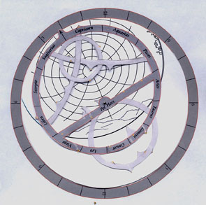
If we measure the Altitude of Polaris we can know our exact LATITUDE. The Latitude, which sailors need to know, is an imaginary circle around the Earth at an exact distance from the Equator. Look at the picture to see how Latitude lines would cut the Earth in sections.
Navigators in Columbus' time would measure the Altitude of Polaris. This angle is the same as the Latitude circle we're on. They could then decide, using their maps, which way to sail to find the nearest coast and they would continue their journey along the coast til they got to a place they recognized. Nowadays, with good clocks, they can know which Longitude line they're on (Longitude lines pass over the Earth like the lines dividing the sections of an orange). New York, for example, is at 41 degrees North Latitude (41 degrees north of the Equator) and 74 degrees West Longitude (74 degrees West of Greenwich, England - the place chosen to represent zero degrees Longitude).
Spider and Web: the Climates
Our astrolabe has three interchangeable discs called CLIMATES. On each of the Climates there is a set of ellipses called ALMUCANTARS. They represent Altitude angles. A star on one of these lines at a particular time (in the next section I'll talk about the star map) would be found at that Altitude in the sky.
The other set of curved lines, which Geoffrey Chaucer compared to the "clawes of a loppe" - a spider's legs, represent the compass directions we can face from wherever we stand. They're called AZIMUTHS. Together, the Azimuths and Almucantars seem to form a web. The spider's body is at that point straight overhead - the ever-present Zenith. It's the center point of the ellipses.
To describe exactly where something is in the sky (as seen from where you are on the Earth) you would have to say how high it is - that is, the Altitude angle - and in which compass direction (North, South, East or West, or any angle point in between).
Nowadays we use the word climate to describe the average weather conditions in a region. But, since most places on the Earth which are at the same Latitude have similar weather conditions, it's easy to see why the spider web plates of the astrolabe are called the Climates. Each one is made for a certain Latitude. The Climates are really space grids, imaginary lines marking off the sky into sections. They help us to measure the exact position of an object in the sky by measuring the exact compass direction we're looking and also the exact Altitude of an object.
Compare the different Climate plates. When the star map of the RETE is correctly laid over each Climate you can begin to see how our view of the "sterres fixes" (the stars in their unchanging constellation drawings) would look as we moved further North or South on our planet Earth. The same star map is distorted differently depending where we're looking from.
We've prepared three Climate grids for our interactive Flash astrolabe. The 20 degree grid corresponds to all locations at 20 degrees Latitude, like Hawaii, Guadalajara, Cuba, Bombay, Hanoi, etc. Forty degrees corresponds to Reno, Denver, Philadelphia, Mallorca, Ankora, Beijing, etc. And sixty degrees is for Ancorage, Oslo, Stockholm, Saint Petersburg, etc. If you're a couple hundred miles North or South of one of these Latitudes, you can still get a pretty clear picture of your local sky by using the nearest Climate. Janus and others offer to construct a personalized astrolabe for any given location.
You can make some very interesting calculations using our three Climates to compare times of sunrise and sunset and the length of days at any time of the year at these three very different Latitudes.
To make a cutout paper version of the astrolabe, first print these three pages - Rete, Moder and Climate40. Pay close attention to where the centers are (the cross of the climate is the zenith; the CENTER is on the North azimuth line of the 40 degree almucantar). For a more durable astrolabe, attach them to a stiff backing before cutting them out. Part of the Climate will have to be trimmed to fit inside the Moder. If you prefer a dark blue background for the Rete click here.
Be creative and make your own design for the star pointers of the Rete (see the Epact website for some beautiful examples). Choose which stars to use and which to ignore - for a useful astrolabe you'll need a couple in each part of the sky, but they have to be stars that you're able to find in the sky, so it's your choice.
Here's my first attempt. Vega is passing thru the zenith.
Rete
The RETE is a star map which also shows the position of the sun for any day of the year. And the planets follow the same path as the sun. The sun, moon and planets (the word planet means "wanderer") are the only objects in the sky which do not stay in a fixed position in a constellation in the sky. BUT, they do stay very close to a pathway called the Ecliptic, which is represented on the astrolabe by the main circle of the Rete where the Zodiac names are inscribed.
In the sixth century (when the astrolabe was invented) if you wanted to see thru something you would cut a hole in it. So, for lack of transparent overlays, the inventors of the astrolabe created the many-pointed filigrees of the Rete in order to see the star map superimposed on the Altitude/compass direction grid of the Climates. Sticking out from various parts of the Rete are pointers marking the position of the brightest stars in the sky (it may be news to you that many stars besides Polaris have names; in fact, ALL the stars which have been observed have been given names). The center that the Rete turns on is the Pole Star - Chaucer's "Hors". Again, the circle with the calendar date markings is the ECLIPTIC, the pathway that the sun and planets seem to follow thru the heavens (that is, the place where we see them as we turn with the Earth on its axis, and as we ride the Earth on its yearly trip around the sun).
The Rete plus the Climates together form the main calculating device of the astrolabe. It's an analog computer, like a slide rule (yes, I realize that's also a thing of the past, but not so far - the Apollo 13 astronauts got to the moon and back on the power of the slide rule). Analog means that the calculations are done along a continuous scale (like measurements are made on a ruler). Like the skill of reading a ruler correctly, to use the astrolabe we have to practice reading the position of a point on a number scale until we can make a good estimate of its numerical value. And then we have to practice setting a numerical value by carefully placing an arrow on a number scale or by placing an exact position on one number scale against an exact position on another number scale.
Sun
Let's try to see more clearly where the sun is. So much light it's hard to see! We see the sun but what's around it is completely lightened out (like something darkened out at night). Six months from today, at midnight, you'll be able to see (looking directly South) the Stars that the sun is hiding at noon today.
Just before the sun rises and just after it sets you can see which constellations are close to it. If you do this regularly during the course of a year you'll notice that the sun's path goes thru the constellations we call the ZODIAC. On any given day we can say that the sun is IN this or that constellation, meaning that from where the Earth happens to be on that day we know that the stars we would see (if there weren't so much light) around and behind the sun would be the ones in that constellation. It's a way of telling what time of year it is.
For any given day let's think of the sun as being at that point on the Ecliptic circle of the astrolabe where that day's calendar date is. Turn the Rete and watch how that point passes thru the horizon, then up thru the spider web (remember the Almucantar ellipses indicate Altitude in the sky) to a high point as it passes the Meridian line, then down thru the other side of the web and below the other side of the horizon line.
The MERIDIAN is the halfway point in the "sun's daily trip" from horizon to horizon. It's the straight Azimuth line indicating the direction South. The NOON line. From the word Meridian we get the abbreviations A.M. and P.M.. Morning is ante (before) meridian; afternoon is post (after) meridian.
The sun reaches its highest point in the sky at midday. Did you notice on the astrolabe exactly how high the sun's point went for the day you just looked at? To see how high the sun will go on a given day simply set the calendar date at the meridian and read off the Altitude using the Almucantar circles.
Sunrise, Sunset, Time of Day
The MODER (mother) of the astrolabe is the back surface which holds (in her "womb") the Climates and the Rete by means of a pin and horse in its center. On the outer rim of the Moder is a time scale. The numbers of this "clock" go counterclockwise because this corresponds to the direction the sun and stars seem to move from our point of view. The marker for this time scale (we'll use it as the hand of our clock) is a little bump on the outer edge of the Rete. This bump with its little arrow pointing to the time scale is called the DENTICLE (from a word meaning tooth) OF CAPRICORN (because it's located in the constellation of Capricorn).
Remember how we just followed the sun thru a calendar day. To find the time of sunrise and sunset for that day first set the calendar date at the Meridian line and, holding the Rete and the Climate together at this point, turn them both until the Denticle points to the twelve on the hour scale (set them at one o'clock if it's Daylight Savings Time). Now hold down the Climate as you turn the Rete to the sunrise position (we're turning back the time and watching for the point where the calendar date - today's sun position on the ecliptic - passes thru the horizon - the Almucantar ellipse of zero altitude). Follow the sun to the other horizon and note the time at that point. Now you can count the number of hours of daylight for this date if you want. These basic operations are explained graphically in the User's Manual.
To tell the time of day review what we just did above. Now turn the astrolabe around, hang it on your thumb, and position yourself and the Alidade so the sun casts a shadow from one slit thru the other. Read the Altitude in degrees. Again on the back side of the astrolabe, make sure that the sun's position (the calendar date) is set at the Meridian and the Denticle at noon (or one o'clock Daylight Time), then hold the Climate in that position and rotate the rete so the sun's position is at the altitude angle (on the almucantar ellipses) corresponding to the angle you just read for its actual Altitude. Supposedly you know whether it's before or after midday (if not, you'll have to wait fifteen minutes or more, take another altitude reading and see if the sun has climbed higher - before midday - or is getting lower - after midday). You can now read the time on the outer scale of the Moder.
During the time between 11AM and 1PM (Standard Time) the Altitude doesn't change much and your estimate of the time can't be very accurate. For other times of day a careful use of the instrument will give you the time accurate to within ten minutes plus or minus. For a more accurate estimate of the time around noon you can use the astrolabe to build a (temporary or more permanent) sundial.
Stars
To orient the astrolabe in relation to the stars always remember to check two points - the Zenith overhead, which is the center point of the ellipses on the climate discs, and the Pole Star, which is the center point that the Rete turns on. Turn so you are facing the Pole Star in the sky and hold the astrolabe so the Zenith is directly above the Horse (Pole Star). This is the view looking North. Turn the Rete so the stars of its map are in roughly the same positions as the stars in the sky. Without changing the position of the Rete (and still holding the astrolabe in the same position in both hands), turn (yourself) around and face directly South. Hold the astrolabe above you now. The line from the Zenith to the Pole Star is pointing behind you (by tilting your head back far enough you may still be able to see the Pole Star). In front of you is where the midday sun would be. If you're familiar with the place you're observing from you probably realize that the sun "rises" over there, on your left (East). It passes thru the midday point in front of you (South) and sets on your right (West). Stars "rise" and "set" in the same direction. They turn counterclockwise around the Horse.
Continue